State Planning Policy

The State Planning Policy (SPP) makes sure the state's interests in planning are protected and delivered as part of local government planning across Queensland.
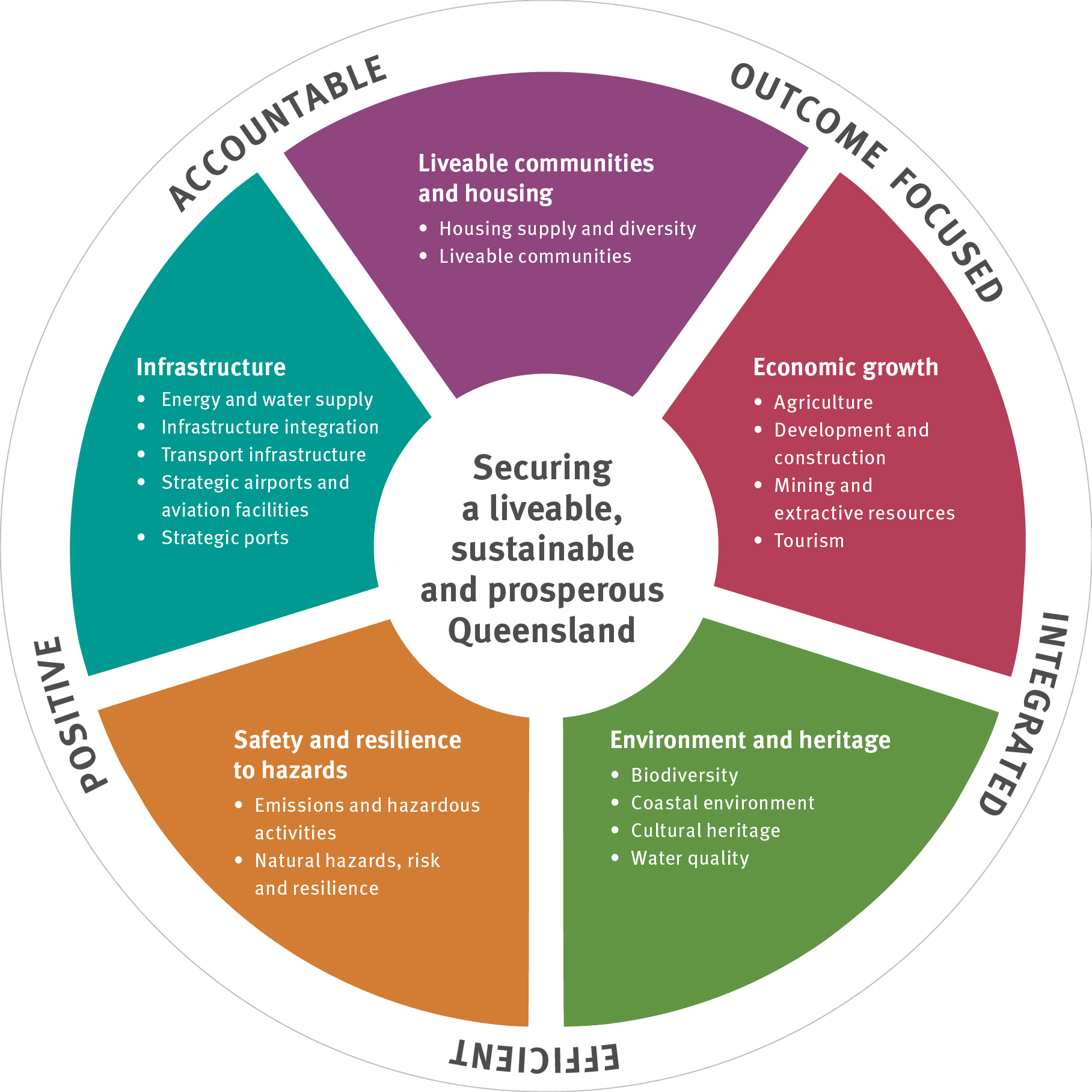
The SPP outlines 17 state interests arranged under five broad themes:
- liveable communities and housing
- economic growth
- environment and heritage
- safety and resilience to hazards
- infrastructure.
The SPP also contains guiding principles to ensure the plan-making and development assessments systems are outcome focused, integrated, efficient, positive and accountable.
Local government uses the SPP when making or amending their local planning instruments, such as a local planning scheme. Local government will also assess aspects of development applications using the SPP if their local planning scheme has not integrated certain state interests.
The state government works with local governments to ensure the state interests are reflected in their local planning scheme. The Planning Minister provides the final approval of these local planning instruments.
Our interactive mapping system provides a spatial representation of matters of state interest. Further information about individual Key Resource Areas is also available below.
Review of the State Planning Policy
The Queensland Government is reviewing the State Planning Policy (SPP).
The SPP forms a critical part of Queensland’s planning framework, ensuring consistent consideration of State interests in development assessment and plan-making.
This review presents an important opportunity to:
- Enhance the clarity and usability of the planning framework
- Improve efficiency
- Ensure responsiveness to current and emerging planning priorities.
The Queensland Government is committed to engaging extensively and widely. There will be an opportunity to provide input and feedback to help shape a revised planning framework that better supports Queensland’s growth, liveability and resilience.
For further information, or to provide your input, please contact us planningforqueensland@dsdilgp.qld.gov.au.
For more information about the related review of State Assessment Referral Agency (SARA) triggers under the Planning Regulation 2017 is available.
Guidance material has been developed to help local government put the SPP into action.
-
- Integrating state interests in planning schemes – Guidance for local government
- Delivery of state interests through the Planning Regulation 2017 – Guidance for local government
- Strategic airports and aviation facilities state interest – Example planning scheme assessment benchmarks
- Natural hazards, risk and resilience state interest – Bushfire - Example planning scheme assessment benchmarks
- Natural hazards, risk and resilience – Bushfire: State Planning Policy – state interest guidance material
-
The SPP interactive mapping system (IMS) is available in a searchable spatial format.
In addition to the SPP IMS, further information about individual key resource areas is available:
- Mining and extractive resources state interest – Key Resource Area reports and maps 1 to 40 (
 23.1 MB)
 - Mining and extractive resources state interest – Key Resource Area reports and maps 41 to 80 (
 27.4 MB)
 - Mining and extractive resources state interest – Key Resource Area reports and maps 81 to 120 (
 22.1 MB)
 - Mining and extractive resources state interest – Key Resource Area reports and maps 121 to 160 (
 23.4 MB)
 - Mining and extractive resources state interest – Key Resource Area reports and maps 161 to 167 (
 6.1 MB)
 - Mining and extractive resources state interest – Key Resource Area reports and maps 168 to 174 (
 5.8 MB)
For further information visit SPP Interactive Mapping System (IMS) - Schedule of amendments.
- Mining and extractive resources state interest – Key Resource Area reports and maps 1 to 40 (
-
- State Planning Policy - April 2016 - Commenced 29 April 2016. Repealed/lapsed 3 July 2017
- State Planning Policy - July 2014 - Commenced 1 July 2014. Repealed/lapsed 29 April 2016
- State Planning Policy - December 2013 - Commenced 2 December 2013. Repealed/lapsed 1 July 2014
Helpful information
- Fact sheet - What is the State Planning Policy?
- Overview - Integrating state interests in planning schemes
- SPP Interactive Mapping System (IMS)
- SPP Interactive Mapping System schedule of amendments
- Aboriginal and Torres Strait Islander guidance material
- Craft brewing industry factsheet
- Healthy and active communities
- Neighbourhood design model code
- Sea turtle sensitive area model code
Last updated: 28 Nov 2025
